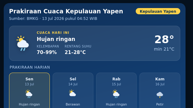
Extent of Forest Area in Indonesia's Customary Territories until August 2025


According to data from the Indigenous Territory Registration Agency (BRWA), as of August 2025, 33.65 million hectares (ha) of indigenous territories have been mapped and registered with BRWA.

- A Small Font
- A Medium Font
- A Bigger Font
You are accessing content Single Data
Premium.
To continue, please subscribe or buy individually.
Enjoy premium access with a more affordable price.
Rp300.000
150.000/month
Access more premium content and exclusive features for customers.
50.000/month
Hanya Rp833 per artikelRead the article immediately “Extent of Forest Area in Indonesia's Customary Territories until August 2025”.
Rp10.000
We accept the following payments:

Related Data

Latest Data Stories


Market Data
| Name | Value | % | |
|---|---|---|---|
| Inflasi yoy (Jun) | 3,34% | +0.26 | |
| Inflasi mom (Jun) | 0,44% | +0.16 | |
| Economic growth | 5,11% | +0.08 | |
| Pertumbuhan ekonomi (yoy) (Q1) | 5,61% | +4.08 | |
| Persentase kemiskinan (Des) | 7,50% | -0.75 | |
| Gini rasio (Sem2) | 0,38 | 0.00 | |
| Nilai Tukar USDIDR | 18.059 | -0.09 | |
| PDB ADHK (Q1) | 3.447,70 | -0.77 | |
| Ekspor Migas (Mei) | 758,10 | -34.38 | |
| Neraca perdagangan (Mei) | -1,61 | -1,907.18 | |
| Impor Migas (Mei) | 4,51 | -1.82 | |
| Ekspor (Mei) | 23,20 | -8.30 | |
| Impor (Mei) | 24,81 | -1.59 | |
| Kunjungan Wisman (Mei) | 1,38 | +10.69 | |
| NTP (Jun) | 114,65 | +0.76 |
Popular Data
